Analysis of the surface propagation of the 2025 Mandalay earthquake made possible by a single surveillance camera!
A team of scientists from several CNRS laboratories has just carried out a precise analysis of the source of the Mandalay earthquake of March 28, 2025 (Mw 7.7) using images from a single CCTV camera. These results were published in the journal Science on October 30, 2025.
On March 28, 2025, a devastating earthquake measuring 7.7 on the magnitude (Mw) scale struck Myanmar along the Sagaing fault near Mandalay. The earthquake caused catastrophic damage: more than 5,400 people were killed, over 11,000 were injured, and thousands were reported missing. Infrastructure suffered significant losses: 120,000 homes, 2,500 schools, numerous temples, and essential transportation networks such as bridges and airports were destroyed. Several historic sites, particularly in Inwa, suffered considerable damage.
This earthquake caused a rupture of more than 450 km along the fault that caused it. The rupture propagated for about 2 minutes on the surface along long horizontal sections, generating a slip of up to 6 m locally. For the first time, the co-seismic slip was filmed by a closed-circuit television (CCTV) camera located just a few meters from the fault trace.
When a surveillance camera reveals the dynamics of an earthquake
By analyzing the images obtained, researchers were able to measure the relative slip at each time interval and deduce the slip rate. The results show a local slip duration of 1.4 seconds and a cumulative slip of approximately 3 meters, during which the surface slip velocity peaked at approximately 3.5 meters per second as the rupture front passed. These results highlight that the seismic rupture at the recording location occurred in a pulsating manner.
Furthermore, using this slip data, researchers were able to calculate for the first time during a real natural earthquake the dynamic properties of seismic rupture, such as stress change, dissipation energy, and energy flow. Although these values are local, they will serve as a reference for seismic rupture modeling.
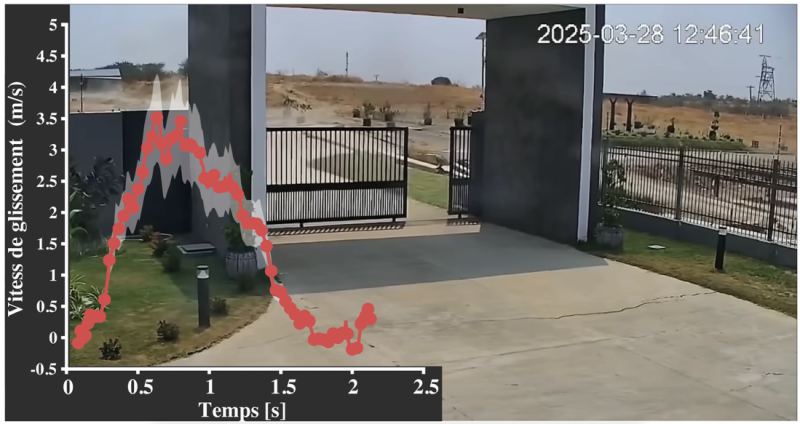
Videosurveillance images used in seismology
The study highlights the potential of a new observational approach in the field of seismology: the strategic deployment of CCTV or high-frequency cameras near active, shallow fault zones.
Such installations could not only capture rapid, co-seismic fault slips, as demonstrated here, but also slower, asismic deformations or post-seismic creep.
Compared to traditional instruments such as broadband seismological stations or continuous GPS networks, video monitoring systems are relatively inexpensive, widely available, and easy to deploy, making them an attractive complementary tool for expanding fault monitoring capabilities.
With proper positioning and calibration, these instruments could provide direct, high-resolution data that can be used to analyze fault behavior across the spectrum of slip modes, opening up new avenues for studying earthquake physics.
CNRS Laboratories involved
- Institut de Recherche en Astrophysique et planétologie (IRAP – OMP)Tutelles : CNRS / CNES / Univiversité de Toulouse
- Laboratoire Géoazur (GEOAZUR – OCA)Tutelles : CNRS / UniCA / IRD / OCAGEOAZUR
- Laboratoire de géologie de l’Ecole Normale Supérieure (LGENS – ECCE TERRA)Tutelles : CNRS / ENS – PSL
- Laboratoire NavierTutelles :École des Ponts ParisTech (ENPC) / Institut Polytechnique de Paris / Université Gustave Eiffel / CNRS
Further Resources
- Scientific article : Latour, S., Lebihain, M., Bhat, H. S., Twardzik, C., Bletery, Q., Hudnut, K. W., & Passelègue, F., Direct estimation of earthquake source properties from a single CCTV camera. (2025). Science, 30(10), eadg1234.
IRAP Contact
- Soumaya Latour, soumaya.latour@irap.omp.eu